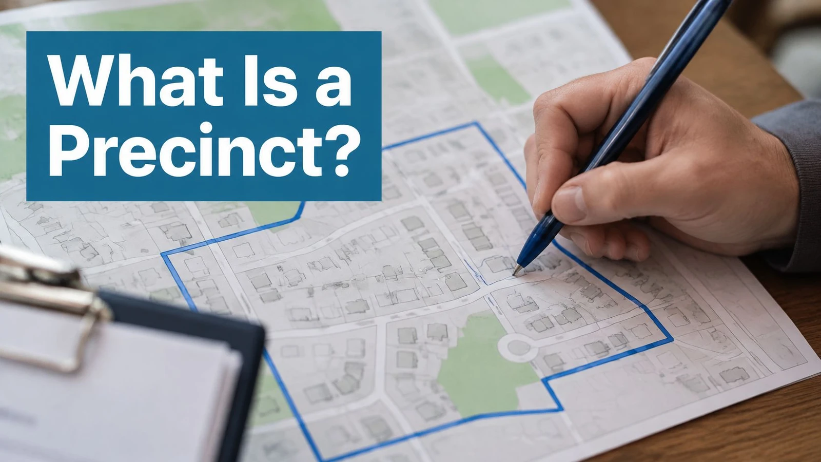
A precinct is the small, legally defined local area that assigns each address to its ballot and voting arrangements. It’s not a building, a neighborhood label, or a representative’s district.
A first-time candidate opens a voter list, sees hundreds of precinct codes beside familiar street names, and has to decide where volunteers should walk first. Two houses across one street can sit in different precincts, receive different ballots, and report their votes in different totals. Understanding that small unit, and checking the version in force for the current election, prevents a team from knocking the wrong doors with the wrong message.
What a Precinct Is in Plain Words
A precinct is a small, legally defined area used to administer elections. It links a voter’s residential address to the contests, ballot, voting arrangements, and reported results that apply to that address.
The U.S. Election Assistance Commission definition describes a precinct as an administrative division of a county or municipality used to determine the contests and issues for which residents are eligible to vote. That’s the official wording behind searches for precinct meaning and precinct definition government. Both phrases point to the same thing, an administrative geography.
A helpful analogy is a post office sorting zone. A home address determines which sorting bin receives the mail. For elections, the address falls inside one precinct, and that assignment determines the ballot style the voter receives. The precinct itself doesn’t elect anybody. It organizes who votes on what, where voting happens, and how the local result is grouped.
Three Jobs in One Small Area
- Assign the correct ballot: The precinct connects an address to the contests and ballot measures that voter may decide.
- Assign voting arrangements: Election officials connect the precinct to a polling place or another voting process.
- Group results for reporting: Ballots from the precinct are counted and reported together, giving campaigns a small-area record of turnout and support.
Local terminology can unsettle new volunteers. Some jurisdictions call a comparable unit a ward, voting district, or election district, even when those words mean something slightly different elsewhere. Campaigns should confirm the local usage before importing, labeling, or sorting voter records. A familiar word on a spreadsheet may not match the term printed on the county map.
The practical answer to what is a precinct is therefore simple, but it has a catch. The precinct is an address-assignment tool, not a permanent neighborhood boundary. Placing it beside wards, districts, and polling places makes its job, and its limits, much easier to see.
Precincts, Wards and Districts Compared
| Unit | Main job | Typical size | Who sets it | Who it represents |
|---|---|---|---|---|
| Precinct | Assigns voters to the correct ballot and voting location | Small, usually a neighborhood-level grouping of voters | County or municipal election authority | No representative directly; several precincts usually sit inside one district |
| Ward | City or borough division that elects councilors | Large enough to elect one or more councilors | City or borough government | One or more councilors |
| Election district | Contiguous area represented by an elected official | A whole state, part of one, or parts of several subdivisions | The authority that draws that office’s district | An elected official |
| Polling place | Physical site where in-person ballots are cast | One facility serving one or several precincts | Local election office | None; one site can serve several precincts |
Read the table bottom-up and the pattern gets clear. Every row either assigns voters to a ballot or decides whose name appears on it.
The Election Assistance Commission guide for local election officials defines an election district as a contiguous geographic area represented by an elected public official, and it can cover an entire state or political subdivision, part of one, or portions of multiple political subdivisions. A ward is generally a city or borough administrative division that typically elects and is represented by one or more councilors. The precinct does neither job directly. Election officials use it to group voters geographically and issue the correct ballot, which makes it the smallest administrative index in the stack: the record that links an address to a ballot style and a reporting unit.
That index is also versioned. Boundaries can be redrawn between elections, so a precinct name or number in last cycle’s voter file may describe different streets this cycle. Campaigns that treat a precinct as a fixed neighborhood get caught by that drift. Campaigns that treat it as an administrative record verify the current version before they build walk lists.
The One Rule to Remember
Precinct lines decide the ballot. District lines decide the representative contests on that ballot.
Several precincts usually fall inside one legislative district, council district, or ward. Precincts can also serve as building blocks when officials draw those larger districts, because the small units already have defined boundaries and voter counts. That relationship explains why a congressional district map contains many precincts, not the other way around. Campaign teams working across levels of government often need both views, including a ZIP code guide to congressional districts, since a ZIP code, district, and precinct never become interchangeable just because they overlap.
Confusion usually begins when a city uses ward as its name for the ballot-assignment unit, or when a voter file labels a field “district” without identifying the office. Volunteers shouldn’t guess from the column heading. The official map and the election office’s terminology control the meaning.
Questions for the Local Election Office
- Which unit assigns the ballot? Ask whether that unit is called a precinct, ward, voting district, or election district locally.
- Which unit provides representation? Identify the council, legislative, or congressional district separately from the ballot unit.
- Do the names match? Confirm whether the precinct name or number in the voter file matches the name on the official map, and whether either changed since the last election.
That short check prevents a common early error: targeting an entire council ward when only certain precincts contain the ballot contest a campaign is running in.
How a Voter’s Address Becomes a Ballot
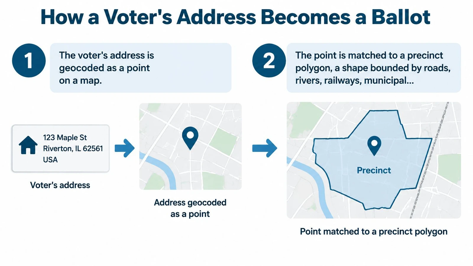
An address becomes a ballot through a chain of geographic matches. The Minnesota Secretary of State’s voting precinct data and maps illustrate the underlying point. A precinct is an administrative geography that determines which contests and ballot measures appear on a voter’s ballot, while the polling place is a separate location assigned to residents of that geography.
- Geocode the address: The voter’s residential address becomes a point on a map.
- Match the point to a polygon: That point falls inside a precinct shape bounded by roads, rivers, railways, municipal limits, or less visible legal lines.
- Set the ballot style: The precinct assignment determines the contests and measures printed for that voter.
- Assign the voting site: Officials assign the precinct to a polling place, which may serve several precincts.
- Report by precinct: After voting, results are reported back at precinct level for that election.
Why One Street Can Split
A boundary may follow the center of a road. When it runs down the middle of one block, the odd-numbered and even-numbered sides can be assigned to different polling places. The houses look like one neighborhood to a canvasser, but the election system treats them as two assignments. A route that walks both sides of every street can therefore cross precincts without showing any visible warning.
A precinct may also be split into parts. Overlapping city, school, utility, legislative, or other jurisdictions can require different contests for addresses inside the same larger precinct outline. Each precinct part receives its own ballot style. Two close neighbors can then see different local races, even though their records share much of the same precinct name.
A precinct label alone doesn’t reveal a voter’s complete ballot or voting site.
Campaign data needs the full join. Teams should connect the precinct to district, ballot style, polling place, and election date before building a list. That joined record tells volunteers which race a household can decide and prevents doorstep information about a contest that isn’t on that voter’s ballot.
Who Draws Precinct Lines and What Changes Them
County or municipal election authorities typically create and maintain precincts. States commonly use those precincts as building blocks when drawing legislative and congressional districts, while local officials use them for registration, ballot styles, polling logistics, and results. The U.S. Census Bureau uses the broader term voting districts for this geography, which helps align election and census records without imposing one local name nationwide.
Precincts aren’t permanent. Officials redraw, split, consolidate, or rename them when populations, district maps, polling capacity, or administrative needs change. Washington’s precinct chapter states that Washington caps precincts at 1,500 active registered voters, and recent official materials cited there include Fairfax County precinct creation and boundary adjustments effective in September 2025 and Arkansas precinct data updated in June 2026 after municipal annexation changes.
Events That Change Precinct Boundaries
| Trigger | What changes | What to verify |
|---|---|---|
| Municipal annexation | Addresses move into a different jurisdiction and precinct | Current city limits and the precinct file for the election year |
| Redistricting | Precinct lines are redrawn to match new district maps | Which district map is in effect for the election |
| Population growth | A precinct is split, or a large precinct is divided to stay within size limits | New precinct names and IDs |
| Polling-site capacity change | A precinct is consolidated or assigned to another polling place | The polling place for each address |
| Overlapping jurisdictions | A precinct is split into parts that receive different ballots | The ballot style for each precinct part |
These changes make a precinct a versioned administrative index, not a fixed neighborhood. The same street address can keep the same house, voter, and local identity while its precinct ID or ballot assignment changes. A spreadsheet saved from a prior cycle may therefore look complete and still be wrong.
Every boundary check needs an election year and boundary version. Campaigns should record the effective date attached to the map they use, then apply that version consistently to voter records, turf, results, and reports for the race underway.
How Precinct Results Set Canvassing Priorities
Past precinct results work best as a ranking tool. In a University of Kentucky study of a Lexington mayoral runoff, which analyzed 287 precincts (285 with targeting information and 264 with complete variables for the full model), each percentage-point increase in prior Democratic support raised the predicted likelihood of targeting by 1.8 points, and 105 of those 285 precincts were designated get-out-the-vote targets.
| Signal | What the Lexington study found | Limit for a campaign team |
|---|---|---|
| Prior Democratic support | Each one-point rise increased the predicted likelihood of targeting by 1.8 points | Reflects past ballots, not current support, so confirm the race and year |
| Turnout percentage | Small, statistically insignificant effect on which precincts were selected | A turnout record alone was a weak ranking signal in this study |
| Targeting designation | 105 of 285 precincts with targeting information were designated get-out-the-vote targets | Designations reflect campaign choices, not a voter outcome |
| Field activity | No statistically significant independent effect after controlling for other factors | Treat results as targeting evidence, not proof of impact |
Prior political support and turnout history answer different questions, so campaigns shouldn’t collapse them into one score without stating the purpose. A precinct with a strong past vote share can still be a poor turnout target if its supporters already vote reliably, and a low-turnout precinct full of friendly voters may matter more to a get-out-the-vote program than to a persuasion one.
From Ranking to Walk List
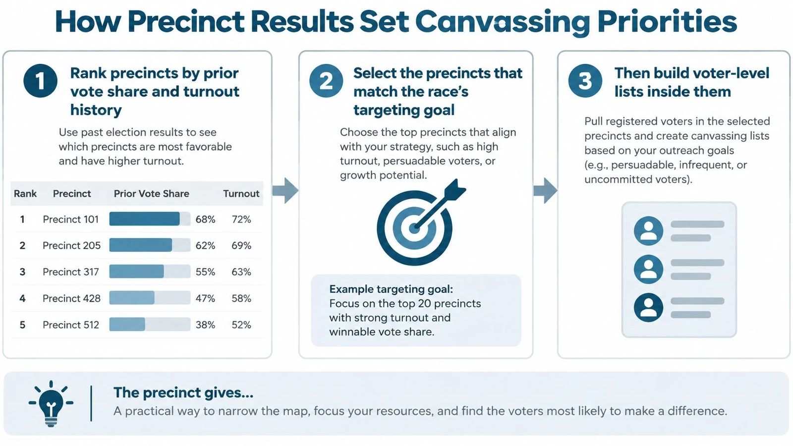
The working sequence starts with ranking precincts by prior vote share and turnout history. A persuasion campaign, a turnout campaign, and a candidate-recognition campaign won’t rank the same places first. Selection should follow the race’s goal and the voters eligible for that contest, not just the largest raw vote total.
Inside each selected precinct, voter records turn an area into doors. Address geography, voting history, party information where available, and contact status produce the walk list. The precinct supplies the boundary. The voter list supplies the households.
Teams can then run that list through turf cutting software to split each selected precinct into walkable routes and assign each route through the role described in the precinct captain guide. Balanced turf matters because one precinct may contain dense apartment blocks while another covers long, low-density streets.
Precinct results guide where to look first. They don’t prove that field work caused the next result.
That caution keeps reporting honest. A strong prior result may reflect candidate appeal, the offices on the ballot, or an older boundary. Because a precinct functions as a versioned administrative index, a result belongs to the boundary that produced it. Precinct history is targeting evidence that must be checked against current eligibility and current voter records before volunteers receive a route.
Common Confusions About Precinct Size and Data
The most damaging misconception is that a precinct is a neighborhood. Election officials draw it for administration, so a precinct can split a street, join unlike blocks, or move while the neighborhood’s identity stays the same. Volunteers who treat it as a community assume shared ballots, shared concerns, and shared voting patterns that the boundary never promised. A precinct works more like an index entry that gets reissued than a place with edges residents would recognize.
- Precincts are large political districts: Typical precincts contain a few hundred to a few thousand voters, far below the scale of the districts that elect officials.
- Every precinct is about the same size: Two precincts drawn in the same county can sit at opposite ends of that range, so copying one precinct’s plan onto another produces uneven workloads.
- Voting district means a separate unit: It’s the Census Bureau’s broader name for the same basic election geography in many contexts.
- Results can be compared across years without checks: Boundary changes require comparison by election year and boundary version.
The National Scale
National counts put those small units in perspective. The peer-reviewed precinct dataset estimated approximately 176,500 voting precincts in the contiguous United States in 2016 and about 177,600 in 2020, close to the 176,933 precincts or precinct equivalents that the U.S. Election Assistance Commission counted in its 2020 survey. In the same dataset, the average precinct recorded roughly 800 votes in 2016 and 900 votes in 2020.
The totals agree without matching exactly, and that is the point: national counts rest on thousands of changing local units. Campaigns that join precinct records to other population sources need care at exactly that seam, which is where the distinction between voter file and census data becomes practical.
Precinct returns are the most granular election results states commonly publish. That detail lets analysts study turnout, support, and ballot measures at neighborhood scale. It also raises the cost of small errors, because a boundary mistake, a stale ID, or an overlooked precinct part can move a total of only a few hundred votes and send a campaign toward the wrong conclusion.
Confirm Your Precinct Before Your First Walk
A short verification routine protects every later step. The Springer analysis of precinct geography and election data systems states that a boundary error can assign a voter to the wrong polling place or ballot contests, while a stale boundary can misallocate canvassing universes and distort precinct-level performance analysis. Precinct identifiers and geometries should therefore be treated as election-cycle-specific.
- Get the official file: Obtain the current precinct map or boundary file from the county or municipal election office.
- Confirm the version: Record the effective date or election version, because an undated map can’t be audited.
- Match local terminology: Confirm whether the unit is called a precinct, ward, voting district, or voting tabulation district.
- Test sample addresses: Geocode target addresses and confirm that each point lands in the expected precinct polygon.
- Check ballot and site: Confirm the polling place and ballot style for every precinct and precinct part.
- Keep a crosswalk: Preserve links to older precinct IDs before comparing current targeting with past results.
- Build turf last: Create walk lists only after those checks pass, then hand each verified route to its captain.
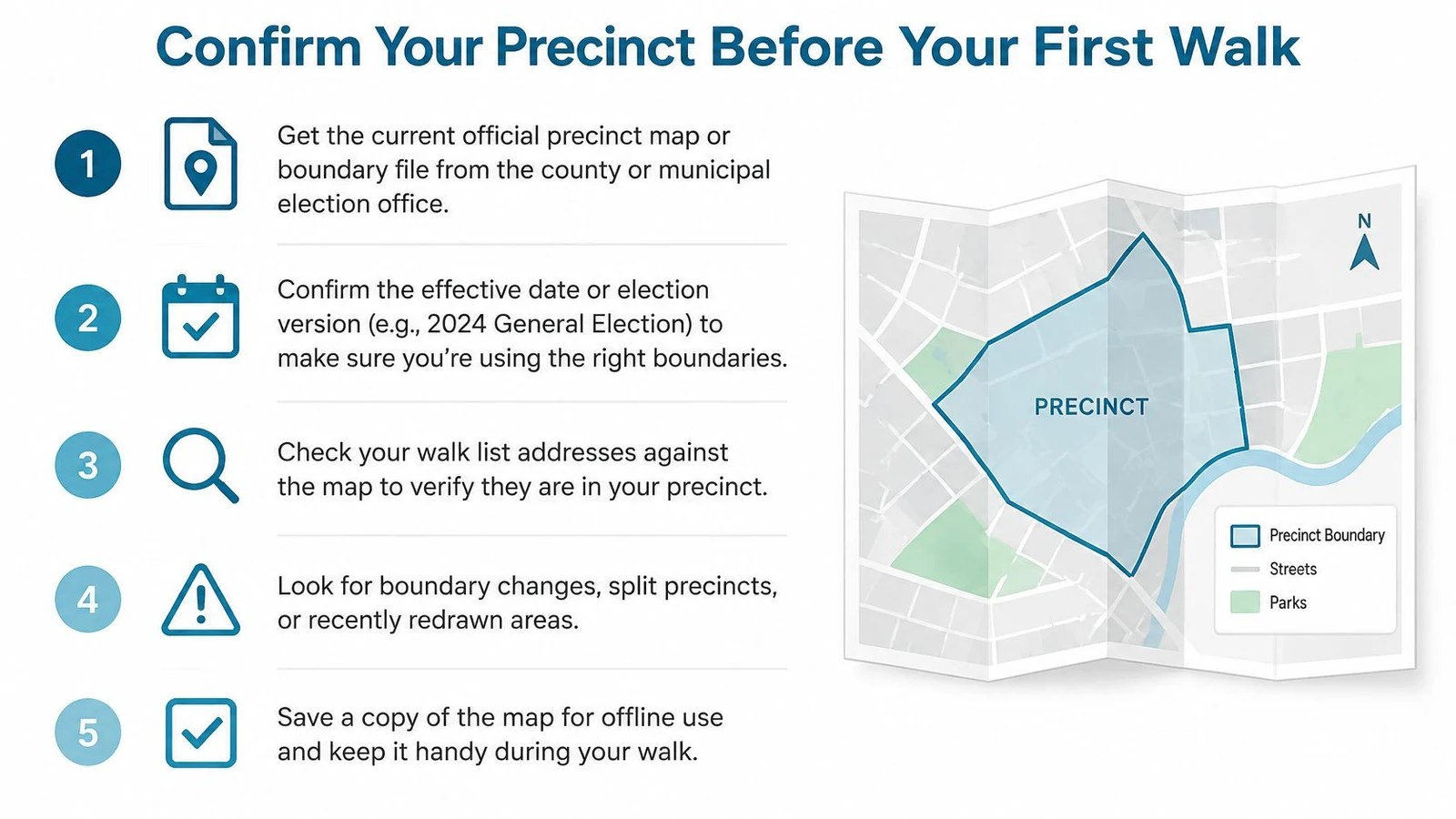
The order matters. Turf built on an old boundary can omit newly annexed homes, mix ballot styles, or place volunteers on streets that no longer belong to the targeted precinct. A ten-address sample often reveals a bad join before an entire field program inherits it.
Before the first shift, the field lead should confirm the assignment with local election officials and freeze the version used for that election. Any later official update gets a new version note, not a silent overwrite.
Turn a verified precinct map into balanced, walkable routes, voter-level lists, and real-time field tracking with support for polygon boundaries, automatic turf cutting, and targeted voter records. Visit doornoc to set up a campaign, match voters inside each precinct, and send captains out with routes built from the current geography.
Looking for a tool to run this? doornoc’s canvassing software bundles voter data, automatic turf cutting, the mobile app, and live reporting in one platform.